FEMA flood zones - mapping and reducing flood risk
FEMA flood zones: understanding and mapping this zoning before buying land conditions the cost of insurance, permits and resale value. Floods remain the leading cause of natural disasters in the United States; knowing how to read FEMA maps and anticipate the BFE makes the difference between a solid deal and a fragile project.
To guide development decisions, FEMA has developed a sophisticated flood risk mapping system that has become essential for all real estate investors.
This article was written by the LandQuire team, which specializes in land investment in the United States. Our experts analyze real estate strategies to support French-speaking investors in their U.S. land acquisition projects. 🔗 Follow LandQuire on LinkedIn.
What are FEMA flood zones?
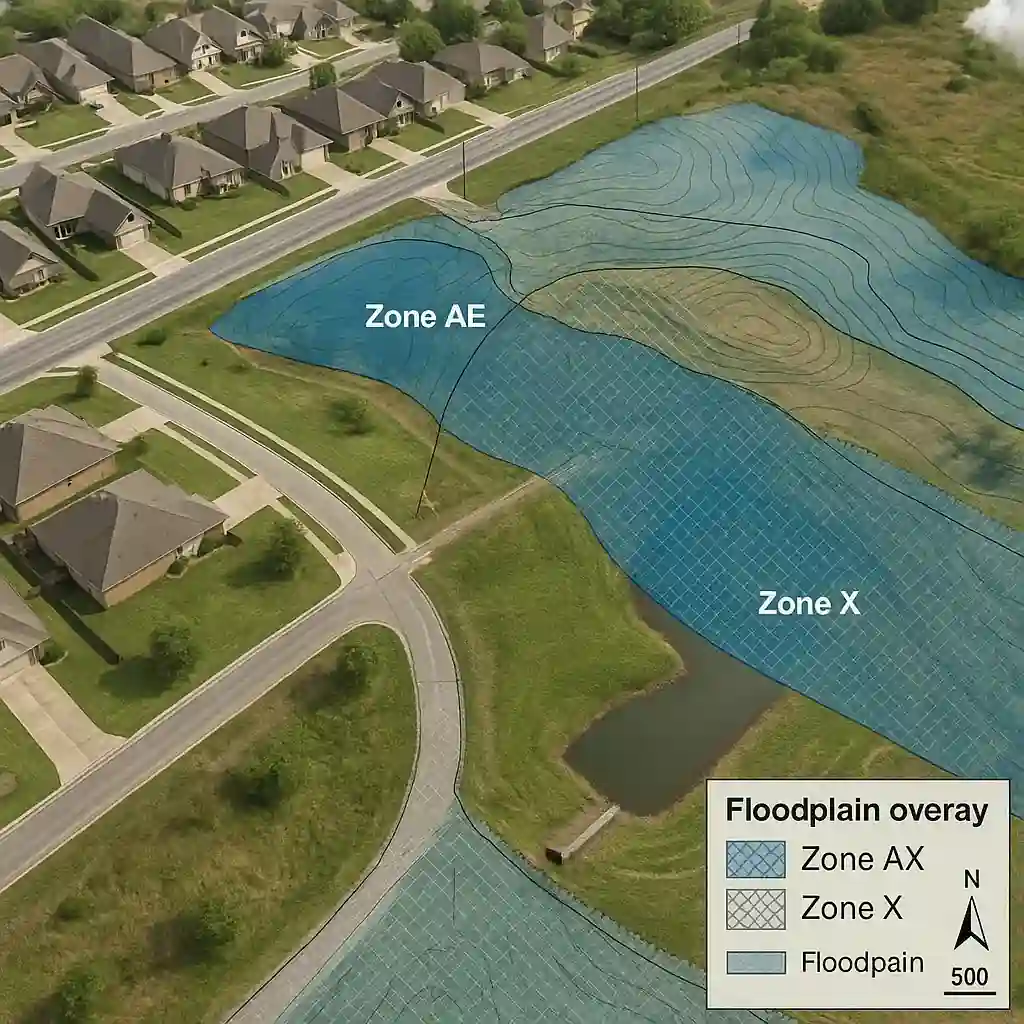
FEMA flood zones are a geographical classification system that identifies areas at risk of flooding throughout the United States. These zones are delineated according to the statistical probability of a flood occurring in a given period. FEMA uses hydrological, topographical and meteorological data to draw up these detailed maps.
Each zone is designated by a letter or combination of letters and numbers, indicating the specific level of risk. This classification directly influences flood insurance requirements, building regulations and real estate investment decisions.
The maps are regularly updated to reflect environmental changes and new scientific data. The system covers all US states, including areas such as Texas where easements can also affect land use.
Detailed classification of flood zones
High-risk zones (A zones)
The A zones represent the areas at highest risk of flooding, with a probability of 1% or more of being flooded each year. This probability corresponds to the so-called 100-year return period flood (1%). FEMA flood zones A include several subcategories depending on the specific characteristics of the terrain.
Zone A Basic indicates a high risk without detailed water level data. AE zones provide precise information on Base Flood Elevation (BFE).
AH zones refer to areas with shallow water accumulation, while AO zones indicate runoff flooding with specified depths. In these zones, federal flood insurance is mandatory for all federally backed mortgages.
New buildings must meet strict elevation and flood resistance standards. These requirements can considerably increase construction and insurance costs.
Moderate-risk zones (zones B and X)
Zones B and X (now grouped under X) present a moderate risk of flooding. These FEMA flood zones include areas protected by levees or located between high- and low-risk zones. Although the risk is reduced, these zones are not totally free of flood danger.
Properties in these areas are not required to have flood insurance, but it is still highly recommended. Around 25% of flood claims occur in moderate or low-risk areas.
Insurance premiums are generally more affordable than in high-risk areas. Investors should nevertheless evaluate these areas carefully, as conditions may change.
Climate change, increasing urbanization and changes in infrastructure may cause a moderate-risk area to become a higher-risk area when the map is revised.
Low-risk areas (unshaded zones C and X)
Unshaded zones C and X correspond to areas with the lowest probability of flooding. These FEMA flood zones present less than a 0.2% annual chance of flooding, or one statistical occurrence every 500 years. However, "low risk" does not mean "no risk".
Flood insurance is not required in these areas, but it may be advisable. Extreme weather events can cause flooding even in theoretically safe areas.
What's more, insurance premiums in these areas are particularly advantageous. For investors, these areas generally offer better opportunities with fewer regulatory constraints.
However, other aspects such as water rights in Texas should be checked, as they can influence the value and use of the land.
Need a quick FEMA flood zones and BFE check for your lot? Ask LandQuire for an express audit.
Impact of flood zones on real estate
Real estate values and marketability
The fact that a property belongs to certain FEMA flood zones significantly affects its market value. Properties located in high-risk zones are generally subject to a discount of up to 10-15% compared with safe zones.
This depreciation reflects additional insurance costs and potential risks for buyers. The liquidity of these properties may also be reduced.
Some buyers systematically avoid flood-prone areas, limiting the pool of potential buyers. Sales lead times are often longer, and price negotiations are more frequent.
Real estate agents must disclose this information to potential buyers. Paradoxically, some properties in flood-prone areas retain their attractiveness thanks to their privileged location (seaside, lake view).
Insurance costs and financing
Flood insurance represents a significant cost for properties in high-risk FEMA flood zones. Annual premiums can vary from a few hundred to several thousand dollars, depending on the zone and the property's characteristics. These recurring costs have a direct impact on the profitability of a rental investment.
The National Flood Insurance Program (NFIP) offers standardized rates, but private insurers sometimes offer more competitive alternatives. Properties that are elevated or have mitigation measures in place can benefit from substantial discounts.
Obtaining an elevation certificate can result in significant savings. Lenders are particularly vigilant when it comes to properties in flood-prone areas.
Some refuse to finance in the riskiest areas, while others require larger down payments. Financing conditions may therefore be less favorable, affecting the accessibility of the investment.
Mapping technologies and tools
Flood Insurance Rate Maps (FIRM)
Flood Insurance Rate Maps are the primary tool for visualizing FEMA flood zones. These detailed maps show the precise boundaries of each risk zone, base flood elevations and areas protected by infrastructure. They are available free of charge from the FEMA Flood Map Service Center (MSC).
FIRMs are regularly updated to incorporate new topographical data, infrastructure modifications and recent flood observations. These revisions can alter a property's classification, impacting its insurance obligations and value.
Owners can contest these changes through a formal appeals process. The correct use of FIRMs requires a certain amount of technical expertise.
Savvy investors often call on professionals to interpret these maps and accurately assess risks. This analysis becomes particularly important when acquiring large tracts of land, where mining rights must also be verified.
Digital tools and applications
Technological evolution has considerably improved the accessibility of FEMA flood zone data. Online platforms now enable instant consultation of the classification of a specific address. Mobile applications even offer geolocation functions for immediate identification of hazards in the field.
These tools often integrate complementary data such as loss history, climate projections and protection infrastructures. In particular, NFIP FloodSmart offers predictive analyses based on artificial intelligence to anticipate future developments in risk zones.
Real estate professionals also use advanced geographic information systems (GIS). These systems overlay flood data with other relevant information from USGS StreamStats.
This multi-layered approach enables a more comprehensive assessment of investment risks and opportunities.
Mitigation and risk reduction strategies
Architectural and construction solutions
Risk reduction in FEMA flood zones requires the adoption of appropriate construction techniques. Raising structures above the base flood level is the most effective measure. Depending on the site's configuration, this can be done using pilings, embankments or raised crawl spaces.
Foundation waterproofing and the use of water-resistant materials in flood-prone areas considerably reduce potential damage. Ventilation openings allow water to drain away while preserving structural integrity.
Although initially costly, these measures generate substantial savings on insurance premiums. Landscaping also plays an important role in mitigation.
Rain gardens, permeable surfaces and the preservation of natural wetlands help reduce runoff. These ecological solutions also enhance the aesthetic appeal of the property.
Community infrastructure
Communities located in FEMA flood zones can implement collective infrastructure projects to reduce risk. The construction of dikes, retention basins and drainage systems improves the protection of entire areas.
These public investments can change the FEMA rating and reduce insurance costs for all residents. FEMA's Community Rating System (CRS) rewards proactive communities with insurance discounts of up to 45%.
Eligible measures include enhanced regulations, public information programs and natural restoration projects. Participation in this program requires a long-term commitment from the municipality, including compliance with EPA NPDES Stormwater standards.
Public-private partnerships often facilitate the financing of these costly infrastructures. In practice, developers can contribute funding in exchange for favorable zoning changes or tax incentives.
FAQ: Essential questions about FEMA flood zones
How do I check a specific address?
To analyze a property's FEMA flood zones, visit the FEMA Flood Map Service Center (MSC), download the corresponding DFIRM, note the zone (AE, AO, VE, X) and the BFE. Overlay this data with the county GIS to identify which portion of the lot falls in SFHA (Special Flood Hazard Area). See also the USGS StreamStats hydrological tool for watershed analysis.
Is NFIP insurance compulsory outside SFHA?
No, insurance is not required outside high-risk zones, but it is strongly recommended. A significant proportion of claims occur in Zone X. Costs drop significantly if the finished floor is above the BFE and if mechanical equipment is raised.
When should I apply for a LOMA/LOMR?
Request a LOMA if the structure is topographically above the BFE despite the map layout. Request a CLOMR/LOMR to revise the map after work or new modeling. These procedures require certified surveys and precise hydraulic calculations.
Which freeboard to target?
Generally allow +1 to +2 ft (≈ 0.30-0.60 m) above the BFE. This is a major lever for reducing insurance premiums and residual risk in FEMA flood zones.
Case study: Subdivision of 48 lots in a mixed zone
Background and challenges
A 42-acre coastal county subdivision has 9% of its surface in Zone AE. The development team strategically placed the roadway and 44 lots in Zone X, concentrating 4 lots near the AE boundary with a freeboard of +1.5 ft above the BFE.
Hydraulic solutions
The project incorporates a detention basin sized for 25-year floods, with emergency spillway, correctly calculated by-pass, and nozzles resized according to NOAA Atlas 14 data. These features comply with local stormwater management requirements.
Financial impact: bonuses and valuation
The typical NFIP premium for an AE-zoned lot is $1,850/year without mitigation. After elevation, devices on elevated technical platforms and FEMA-compliant enclosure openings, the target premium reaches ≈ $1,050/year. Lots in Zone X appreciate +6-8% versus comparables, with a reduced absorption period.
Optimize without disproportionate cost overruns
By adjusting the layout and elevation in FEMA flood zones, the developer avoids a costly LOMA, secures the permit and improves marketing. The combination of elevation + construction details (ventilation, overhead equipment) lowers both risk and premium.
Outlook: maps and climate
FEMA flood zones will evolve with urbanization and climate. More frequent DFIRMs, LiDAR/drone data and climate models refine SFHA boundaries and BFEs. For investors: check FIS date, provide freeboard (+1 to +2 ft ≈ 0.30-0.60 m) and integrate robust stormwater management solutions early.
Flood-smart strategy
Combine :
- implantation outside SFHA whenever possible;
- reasonable freeboard;
- well-sized basins ;
- scheduled HOA maintenance.
This approach reduces premiums and risks while improving resale liquidity.
Pro resource
For further information, consult theAssociation of State Floodplain Managers (ASFPM) for technical resources and feedback.
Regulatory and legal implications
Disclosure obligations
U.S. regulations impose strict disclosure obligations concerning FEMA flood zones. Sellers must inform potential buyers of their property's flood status. This disclosure includes known claims history and applicable insurance obligations. Failure to disclose this information may result in legal liability for the seller.
Real estate agents also have professional responsibilities in flood risk disclosure. They must ensure that their clients understand the financial and practical implications of buying in a flood zone. This obligation extends to potential impacts on property resale and rental.
Lenders are required to inform borrowers of flood insurance requirements prior to loan finalization. This notification must be clear and enable the borrower to assess the total cost of ownership. Violations of these obligations may result in regulatory sanctions and legal recourse.
Legislative developments
Legislation concerning FEMA flood zones is constantly evolving in response to emerging challenges. Recent reforms to the National Flood Insurance Program aim to improve the solvency of the system while maintaining accessibility to insurance. These changes include rate adjustments and mitigation incentives.
States are also developing their own initiatives to complement the federal program. Some offer additional insurance programs or tax incentives for risk reduction measures. This multi-layered approach strengthens protection for homeowners while encouraging responsible investment.
The growing integration of climate considerations into urban planning is influencing local regulations. Municipalities are adopting stricter building standards and development restrictions in sensitive areas. These regulatory changes are gradually redefining real estate investment opportunities.
Conclusion
A thorough understanding of FEMA flood zones is a fundamental element of any real estate investment strategy in the United States. These classifications, far from being mere technical designations, directly influence property values, insurance costs and financing opportunities. The constant evolution of these zones, accelerated by climate change and increasing urbanization, requires constant vigilance on the part of investors.
Modern technological tools facilitate access to this crucial information, but its correct interpretation remains essential. The wise investor systematically integrates flood zone analysis into his due diligence process, along with an examination of easements, water rights or mineral rights. This comprehensive approach enables us to seize the best opportunities while minimizing the risks inherent in investing in U.S. land.
To validate the flood risk of your plot and secure your acquisition, contact LandQuire for expert advice.
Field due diligence checklist
Documents and cartography
Download the DFIRM and FIS (Flood Insurance Study) from the FEMA MSC. Record the exact zone and BFE. Check the date of the FIS/DFIRM (maps are sometimes out of date). Overlay with county GIS and land registry for accurate analysis of property lines versus FEMA flood zones.
Field inspection
Visit the site, identifying low spots, culverts, ditches, existing dikes and high-water marks. Check local stormwater management requirements, riparian buffers and NPDES permits. Obtain an Elevation Certificate from a surveyor if close to SFHA.
Legal and financial aspects
Check existing drainage/access easements and private structures. Compare NFIP rates vs. private insurance on FloodSmart. Schedule HOA (Homeowners Association) maintenance for grates, ditches and catch basins.
In Texas, carefully examine easements, water rights and mineral rights before signing.
Future developments and prospects
FEMA flood zones will continue to evolve with urbanization and climate. More frequent DFIRM updates, the use of Lidar/drone data and climate models are refining the limits of SFHA and BFEs. For investors, the rule is simple: check the FIS date, anticipate a margin (freeboard) and integrate robust rainwater management solutions from the outset.
Competitive advantage comes from accurate map reading combined with flood-smart design. A combination of non-SFHA siting, reasonable freeboard (+1 to +2 ft), well-sized basins and HOA maintenance reduces premiums and risks, while improving resale liquidity.
For more technical information on flood management, consult theAssociation of State Floodplain Managers (ASFPM), which offers specialized resources for professionals.